
Routes to the Klondike
On August 16, 1896,
an American prospector named George Carmack, his
Tagish wife Kate Carmack, her brother Skookum Jim, and their
nephew Dawson Charlie were travelling south of the Klondike
River. Following a suggestion from Robert Henderson, a
Canadian prospector, they began looking for gold on Bonanza Creek, then
called Rabbit Creek, one of the Klondike's tributaries. It’s not clear who
discovered the gold, George Carmack or Skookum Jim, but the group agreed to let
George Carmack appear as the official discoverer because they feared that
authorities would not recognize an Indigenous claimant.
In any event, gold
was present along the river in huge quantities. Carmack measured out four
claims (strips of ground that could later be legally mined by the owner) along
the river including two for himself, (one as his normal claim, the second as a
reward for having discovered the gold) and one each for Jim and Charlie. The
claims were registered the next day at the police post at the mouth of the
Fortymile River and news spread rapidly from there to other mining camps in the
Yukon River valley.
By the end of
August, all of Bonanza Creek had been claimed by miners. A
prospector then advanced up into one of the creeks feeding into Bonanza, later
to be named Eldorado Creek. He
discovered new sources of gold there, which would prove to be even richer than
those on Bonanza. Claims
began to be sold between miners and speculators for considerable sums.
Just before
Christmas, word of the gold reached Circle City. Despite the winter, many
prospectors immediately left for the Klondike by dog-sled, eager to reach the
region before the best claims were taken. The outside world was still largely
unaware of the news and, although Canadian officials had managed to send a
message to their superiors in Ottawa about
the finds and influx of prospectors, the government did not give it much
attention.
The winter
prevented river traffic, and it was not until June 1897 that the first boats
left the area, carrying the freshly mined gold and the full story of the
discoveries.
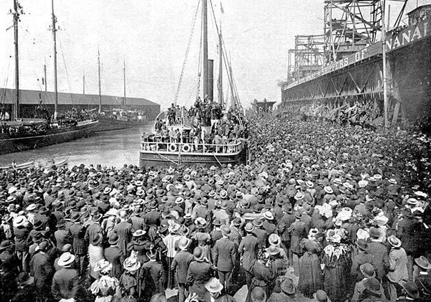
SS
Excelsior leaving San Francisco for the Klondike
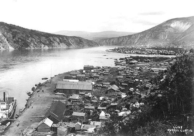
When news reached Seattle and San Francisco, a stampede ensued with an estimated 100,000 people trying to reach the Klondike goldfields, though only 30,000-40,000 eventually did. The town of Dawson City was founded at the confluence of the Klondike and Yukon rivers and grew from a population of 500 in 1896 to 30,000 by the summer of 1898. Once again prospectors ignored the First Nations people already living in the area and they were forcibly moved to a reserve.

There
were three principal routes to the Klondike, the All-Canadian Route, crossing
swamps, river gorges and mountains which few took, the All-Water Route that
followed the Yukon River from its delta in the Bering Sea to Dawson City but
was only open when the river wasn’t frozen, and the more popular Skagway/Dyea
Route that led over the Chilkoot Pass/White Pass and then down the Yukon River
to Dawson City.
At the start of the gold rush the Canadian government introduced rules requiring anyone entering Yukon Territory to bring with them a year's supply of food. Typically, this weighed around 1,150 pounds and by the time camping equipment, tools and other essentials were included, a typical traveller was transporting as much as 2,000 pounds in weight. All of this had to be transported from the dock at Skagway or Dyea up and over the Chilkoot or White Pass in multiple trips until the prospector made it to the Yukon border and from there could connect to the head of the Yukon River.

It was an arduous process to get to Dawson City and then the work really began as miners first had to clear the ground of vegetation, then dig through the permafrost to get to the bedrock where the gold could be found after the dirt and gravel were sluiced and panned with water to separate the heavier gold from the gravel. In the end very few became rich and most who did find gold lost their fortunes in the following years. By 1899 it was mostly over but in the intervening years Dawson City became legendary for its 24 hour saloons, brothels, dance hall girls, and champagne drinking.


On June 13th, 1898 the territory of Yukon was created from the North-West Territories. Ironically it was the gold rush that uncovered the skeletal remains of wooly mammoths, scimitar cats, and other creatures from Beringia, the ancient entrance point to North America, that until now had lay hidden and preserved under the permafrost.


On September 1st 1905 the Provinces of Alberta and
Saskatchewan were created from the North-West Territories.

On May 15th, 1912 the Provinces of Manitoba, Ontario, and
Quebec were expanded with territory from the North-West Territories. The
borders of Canada and its Provinces would remain unchanged for nearly 100 years
until the remaining Northwest Territories were divided in half and the Territory of
Nunavut was created on April 1st 1999.